
Trail motorcycle GPS · France, Spain, Portugal
Trail motorcycle GPS
for tracks
and dirt roads
Plan your trail rides and loops: CapTrail works out the route along tracks and dirt roads, shows protected areas on the map and can route around them. Out on the trail, it guides you by voice, turn by turn.
Web app, with the same account as the mobile app.
7-day free trial on your first subscription, then €4.99 per month or €29.99 per year.
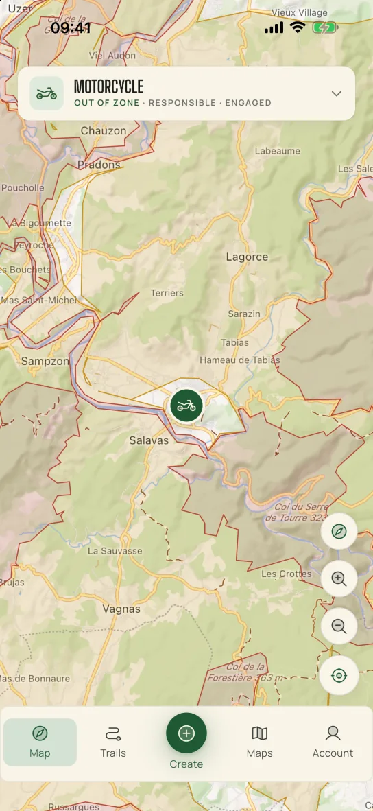
Map: OpenFreeMap © OpenMapTiles © OpenStreetMap contributors, EU-DEM relief. Map credits
A motorcycle GPS built for tracks
Create the route, pick your style, see the zones and let CapTrail guide you.
Point-by-point motorcycle routes
Drop your points on the map: CapTrail works out the route along tracks and dirt roads. Undo, redo, move a point. Distance, elevation gain and duration are shown before you set off.
Comfort or Engaged
Two riding styles. Comfort leaves out the hardest tracks and accepts more road, for a big adventure bike, loaded or two-up. Engaged puts tracks before tarmac.
Protected areas on the map
Natura 2000 sites, ZNIEFF areas, parks and reserves appear in red or orange. Choose Responsible or Sensitive and the route goes around them when possible.
Military zones
Military zones are excluded from route calculation.
Voice guidance
Tilted map view, turn-by-turn voice instructions, beep and banner at junctions. Remaining distance, time and elevation gain always on screen.
Automatic rerouting
An alert with vibration warns you if you leave the route, and the route is recalculated (connection required). Track closed? Report a blocked road.
GPX import and export
Import your GPX tracks and waypoints, and export your routes to your GPS or other apps.
On a computer too
Plan your rides on a big screen with the web app, then find them in the mobile app with the same account.
France, Spain, Portugal
Routes and zones cover mainland France, peninsular Spain and mainland Portugal.
Comfort or Engaged: pick your style
The style changes how the route is calculated. Switch whenever you like.
Comfort
Tracks first, except the hardest ones, with more road than Engaged to link your points. Suited to a big adventure bike, loaded or two-up.
Engaged
Tracks before tarmac: the route takes the tracks whenever it can, even if the ride gets longer. For riders at ease on dirt.
In both styles, non-motorised footpaths are excluded, and you choose whether to include motorways.
Natura 2000 and protected areas, on your map
CapTrail shows protected natural areas and lets you choose how the route takes them into account.
In France: Natura 2000, ZNIEFF, parks and reserves. In Spain: protected natural areas and the Natura 2000 network. In Portugal: protected areas, special protection areas and Ramsar sites.
Military zones are excluded from route calculation.
Three zone settings
- Free
- Zones stay on the map, but the calculation ignores them. This is the starting setting.
- Responsible
- The route goes around red zones when possible.
- Sensitive
- The route also goes around orange zones when possible.
CapTrail does not replace road signs or local orders: you remain responsible for complying with local regulations (in France, the law of 3 January 1991).
Plan your rides on a computer
The CapTrail web app lets you draw and edit your motorcycle routes on a big screen. Sign in with the same account as in the mobile app: your routes will be waiting on your phone. Guidance itself happens in the mobile app.
Coverage
Mainland France, peninsular Spain and mainland Portugal. App available in French, Spanish, Portuguese and English.
The CapTrail app for iPhone, iPad and Android
Create your account, enjoy the 7-day free trial and plan your first ride.
Coming soon to the App Store and Google Play.
Frequently asked questions
What is CapTrail?
A trail motorcycle GPS. It plans routes along tracks and dirt roads, shows protected areas on the map and guides you by voice during your ride.
How is it different from a road motorcycle GPS?
A road motorcycle GPS plans its routes on tarmac. CapTrail plans the route along tracks and dirt roads: Comfort accepts more road and leaves out the hardest tracks, Engaged puts tracks before tarmac. It also shows protected areas on the map, can route around them and guides you by voice, turn by turn.
Does CapTrail suit a big adventure bike?
Yes. On a big adventure bike, especially a loaded one, choose the Comfort style: the route accepts more road and leaves out the hardest tracks. Engaged puts tracks before tarmac, for riders at ease on dirt. In both styles, non-motorised footpaths are excluded from the calculation.
Which countries are covered?
Mainland France, peninsular Spain and mainland Portugal, for both route planning and zones.
Where do the zones come from?
From public sources: INPN in France, the Ministry for the Ecological Transition (MITECO) in Spain and ICNF in Portugal. With Responsible or Sensitive, the route goes around them when possible; with Free, they are only displayed. Military zones are excluded from route calculation. CapTrail does not replace road signs or local orders.
Do I need an internet connection?
Yes: to calculate a route, for automatic rerouting if you leave the route and for the alerts when you enter a zone.
Can I import my own tracks?
Yes. CapTrail imports and exports GPX files: your tracks become routes, and your GPX waypoints can be added to your routes.
What language is the voice guidance in?
The language of your phone: French, Spanish, Portuguese or English.
How much does CapTrail cost?
One subscription: €4.99 per month or €29.99 per year, with a 7-day free trial on your first subscription. It renews automatically and you can cancel at any time.
Can I use CapTrail on foot?
Yes, a Pedestrian mode also plans walking routes.
What do you do with my data?
CapTrail shows no advertising and does not sell your data. The details are in the privacy policy.